With effect from 1st October 2021, China is introducing the new Pedestrian and Bicycle Transport System Planning Standards (GB/T51439-2021 城市步行和自行车交通系统规划标准). This regulation is the first to set out common standards for pedestrian transport planning on a national level.
What is the purpose of the national standards?
Against the backdrop of policies evolving from a purely car-centric approach in cities to planning for transport-oriented development, the national standards represent a major step in planning for walking and cycling infrastructure.
The Pedestrian and Bicycle Planning Standard’s code is GB/T, which means that it is a recommended standard. Recommended standards are more flexible and adaptable, which make them easier to implement on a large scale.
Background: national standards
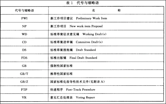
There are eleven categories of national standards linked to the process of drafting and enacting them. For the purpose of this article, understanding the following three categories is key :
GB (国标 – Guo Biao in Chinese) designates mandatory standards where parties can be held responsible if the standard is not followed.
GB/T (推荐性国家标准 – Tuijianxing Guojia Biaozhun in Chinese) are recommended standards where parties can decide whether or not to use this standard.
GB/Z (国家标准化指导性技术文件 Guojia Biaozhunhua Zhidaoxing Jishu Wenjian) are national standardisation technical guidance documents. These documents are used as a guide for fields where technical aspects are still under development.
Until now, there has not been a common set of standards for pedestrian and bicycle infrastructure. Several cities such Shanghai and Chengdu published their own Street Design Guidelines. However, these may only be used as reference materials and there is no mandatory requirement for parties to follow these guidelines.
The national standards provide a common ground for all cities in China. Those cities that did not have local standards for pedestrian planning can now apply the national standards. It may also encourage local authorities to create local standards adapted to their context that will prevail over the national standards.
What are the key changes in the new standards?
The greatest change in the new standards stems from the creation of transport zones. These are defined based on the density of people flows, function and positioning, street network conditions, and boundary elements such as topography, rivers or railways. Each city can define its own zones according to local conditions.
Zone I: Important Transport Zone, defined by (but not restricted to):
• Areas where walking and biking activities are dense
• Zones where there is a presence of core functions.
• Places where there are a concentration of citizen activities and there are public facilities
• Zones near a transport hub or station
• Zones where the street network is dense enough to allow a continuous and accessible pedestrian or bike network.
Zone II: Common Transport Zone, located outside the Zone I
Special zones are referred to regarding footway widths: railway stations, shopping malls, hospitals and schools
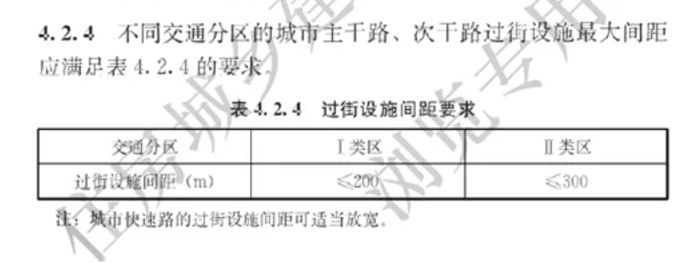
This document can be now used as a planning lever in transport schemes, with responses adapted to context. Moreover, the standards are flexible enough so that transport zones can be implemented into local context. Previously, planning standards did not take into account the surrounding environment, which led to the creation of large and high-speed arteries with the same characteristics regardless if they were in a high density area or not (see our article Pedestrian Transport Planning for TODs in Urban China ). The adoption of these standards means that pedestrian planning tools will play a greater role in the transport planning process. For example, distance between crossings for pedestrians should be inferior or equal to 200m in zone I against 300m in Zone II.
How will the standards affect individual developments, masterplans and regeneration schemes?
The standard provides a methodology to promote pedestrian and bicycle transport planning in individual projects. Planning tools, standards and calculations are provided, which allow for the definition of different transport zones and the application of differentiated and more context-specific design solutions.
For individual projects, this means that pedestrian and bicycle infrastructure and its integration with surrounding areas can be assessed, benchmarked and optimised according to the zone in which it is located. Therefore, it gives professionals in the design, construction and property sectors additional tools to develop people-oriented cities and reduce the legacy impacts of car-centric planning.
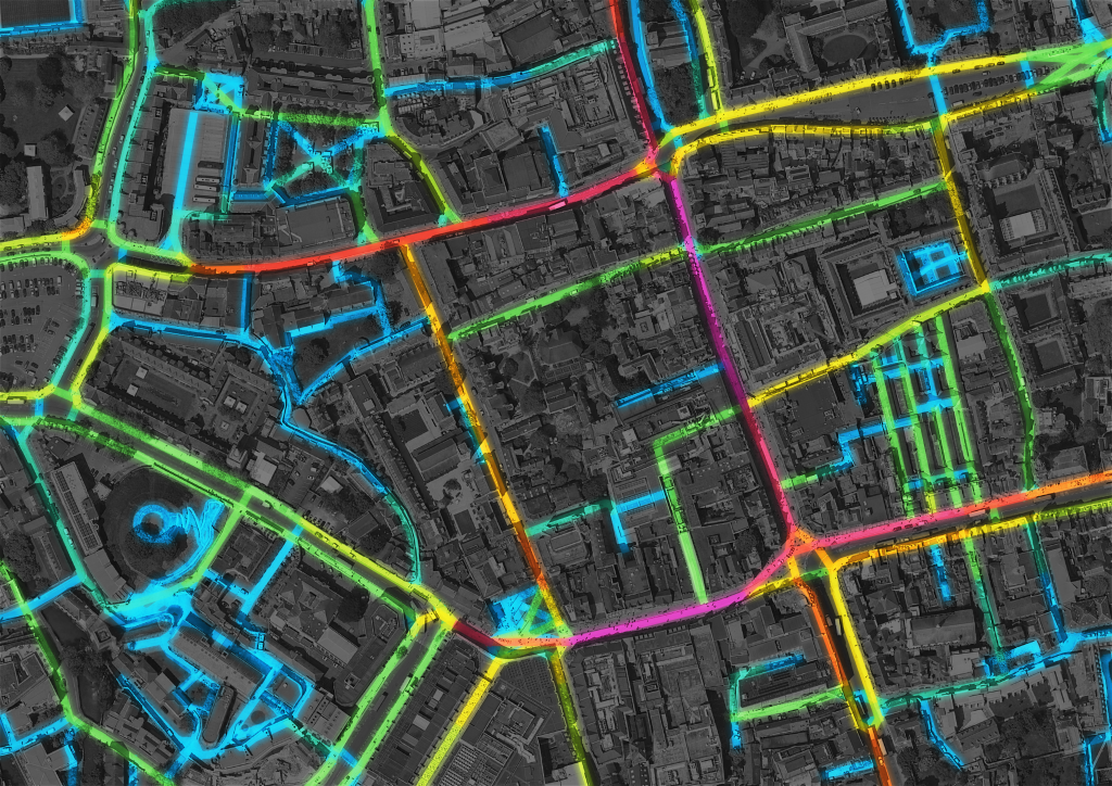
At Wedderburn Transport Planning we focus on transport planning and people movement analysis. We analyse the spatial structure of neighbourhoods and visualise local movement patterns using Spatial Network Analysis tools. This evidence-based approach to urban planning provides architects and planners with quantitative measures to benchmark urban layouts against existing neighbourhoods. We undertake pedestrian movement analysis and forecasting for masterplans, interchange and retail environments. We also use flow analysis and micro-simulation to evaluate the safety and comfort of proposed designs.
There are signs that the pedestrian environment in Chinese cities is about to change. It is time to put our tools to good use!